Zoom Earth - Live Weather Map
ବିଜ୍ଞାପନ ଅନ୍ତର୍ଭୂକ୍ତଆପ୍ ମଧ୍ୟରେ କ୍ରୟଗୁଡ଼ିକ
4.6star
151ହଟି ସମୀକ୍ଷା
1ନି+
ଡାଉନଲୋଡ

PEGI 3
info


ଏହି ଆପ୍ ବିଷୟରେ
TRACK THE WEATHER IN REAL-TIME
Zoom Earth is an interactive weather map of the world and a real-time hurricane tracker.
Explore the current weather and see forecasts for your location through interactive weather maps of rain, wind, temperature, pressure, and more.
With Zoom Earth, you can track the development of hurricanes, storms, and severe weather, monitor wildfires and smoke, and stay aware of the latest conditions by viewing satellite imagery and rain radar updated in near real‑time.
SATELLITE IMAGERY
Zoom Earth shows weather maps with near real-time satellite imagery. Images are updated every 10 minutes, with a delay between 20 and 40 minutes.
Live satellite images are updated every 10 minutes from NOAA GOES and JMA Himawari geostationary satellites. EUMETSAT Meteosat images are updated every 15 minutes.
HD satellite images are updated twice a day from NASA polar-orbiting satellites Aqua and Terra.
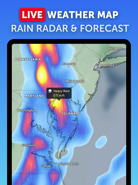
RAIN RADAR & NOWCAST
Stay ahead of the storm with our weather radar map, which shows rain and snow detected by ground-based Doppler radar in real-time, and provides an instant short-term weather forecast with radar nowcasting.
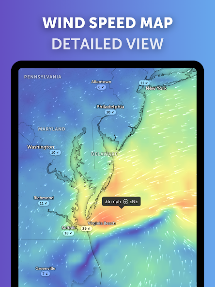
WEATHER FORECAST MAPS
Explore beautiful, interactive visualizations of the weather with our stunning global forecast maps. Our maps are continually updated with the latest weather forecast model data from DWD ICON and NOAA/NCEP/NWS GFS. Weather forecast maps include:
Precipitation Forecast - Rain, snow, and cloud cover, all in one map.
Wind Speed Forecast - Average speed and direction of surface winds.
Wind Gusts Forecast - Maximum speed of sudden bursts of wind.
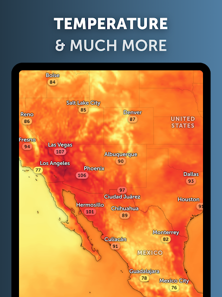
Temperature Forecast - Air temperatures at 2 meters (6 feet) above the ground.
"Feels Like" Temperature Forecast - Perceived temperatures, also known as apparent temperature or heat index.
Relative Humidity Forecast - How air moisture compares to temperature.
Dew Point Forecast - How dry or humid the air feels, and the point at which condensation occurs.
Atmospheric Pressure Forecast - The average atmospheric pressure at sea level. Low-pressure areas often bring cloudy and windy weather. High-pressure areas are associated with clear skies and lighter winds.
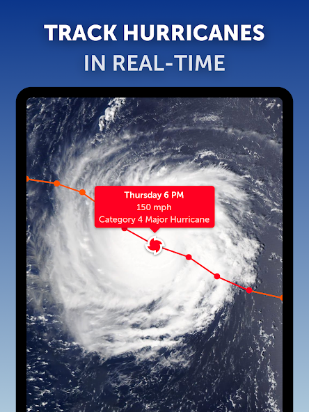
HURRICANE TRACKING
Follow hurricanes from development to category 5 in real-time with our best-in-class tropical tracking system. Information is clear and easy to understand. Our hurricane tracking weather maps are updated using the very latest data from NHC, JTWC, NRL, and IBTrACS.
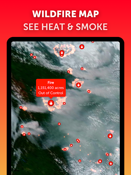
WILDFIRE TRACKING
Monitor wildfires with our active fires and heat spots overlay, which shows points of very high temperature detected by satellite. Detections are updated daily with data from NASA FIRMS. Use in conjunction with our GeoColor satellite imagery to see the movement of wildfire smoke and monitor fire weather in near real-time.
CUSTOMIZATION
Adjust temperature units, wind units, time zone, animation styles, and many more features with our comprehensive settings.
ZOOM EARTH PRO
More features are available through auto-renewable subscriptions. Payment will be charged to your Google Play account at the confirmation of purchase. The subscription will automatically renew at the end of each billing period and be charged within 24 hours, unless auto-renew is turned off at least 24 hours before the end of the current period. For further information, please read our Terms of Service.
LEGAL
Terms of Service: https://zoom.earth/legal/terms/
Privacy Policy: https://zoom.earth/legal/privacy/
Zoom Earth is an interactive weather map of the world and a real-time hurricane tracker.
Explore the current weather and see forecasts for your location through interactive weather maps of rain, wind, temperature, pressure, and more.
With Zoom Earth, you can track the development of hurricanes, storms, and severe weather, monitor wildfires and smoke, and stay aware of the latest conditions by viewing satellite imagery and rain radar updated in near real‑time.
SATELLITE IMAGERY
Zoom Earth shows weather maps with near real-time satellite imagery. Images are updated every 10 minutes, with a delay between 20 and 40 minutes.
Live satellite images are updated every 10 minutes from NOAA GOES and JMA Himawari geostationary satellites. EUMETSAT Meteosat images are updated every 15 minutes.
HD satellite images are updated twice a day from NASA polar-orbiting satellites Aqua and Terra.
RAIN RADAR & NOWCAST
Stay ahead of the storm with our weather radar map, which shows rain and snow detected by ground-based Doppler radar in real-time, and provides an instant short-term weather forecast with radar nowcasting.
WEATHER FORECAST MAPS
Explore beautiful, interactive visualizations of the weather with our stunning global forecast maps. Our maps are continually updated with the latest weather forecast model data from DWD ICON and NOAA/NCEP/NWS GFS. Weather forecast maps include:
Precipitation Forecast - Rain, snow, and cloud cover, all in one map.
Wind Speed Forecast - Average speed and direction of surface winds.
Wind Gusts Forecast - Maximum speed of sudden bursts of wind.
Temperature Forecast - Air temperatures at 2 meters (6 feet) above the ground.
"Feels Like" Temperature Forecast - Perceived temperatures, also known as apparent temperature or heat index.
Relative Humidity Forecast - How air moisture compares to temperature.
Dew Point Forecast - How dry or humid the air feels, and the point at which condensation occurs.
Atmospheric Pressure Forecast - The average atmospheric pressure at sea level. Low-pressure areas often bring cloudy and windy weather. High-pressure areas are associated with clear skies and lighter winds.
HURRICANE TRACKING
Follow hurricanes from development to category 5 in real-time with our best-in-class tropical tracking system. Information is clear and easy to understand. Our hurricane tracking weather maps are updated using the very latest data from NHC, JTWC, NRL, and IBTrACS.
WILDFIRE TRACKING
Monitor wildfires with our active fires and heat spots overlay, which shows points of very high temperature detected by satellite. Detections are updated daily with data from NASA FIRMS. Use in conjunction with our GeoColor satellite imagery to see the movement of wildfire smoke and monitor fire weather in near real-time.
CUSTOMIZATION
Adjust temperature units, wind units, time zone, animation styles, and many more features with our comprehensive settings.
ZOOM EARTH PRO
More features are available through auto-renewable subscriptions. Payment will be charged to your Google Play account at the confirmation of purchase. The subscription will automatically renew at the end of each billing period and be charged within 24 hours, unless auto-renew is turned off at least 24 hours before the end of the current period. For further information, please read our Terms of Service.
LEGAL
Terms of Service: https://zoom.earth/legal/terms/
Privacy Policy: https://zoom.earth/legal/privacy/
ଗତ ଅପଡେଟର ସମୟ
ଡେଭେଲପରମାନେ ଆପଣଙ୍କ ଡାଟାକୁ କିପରି ସଂଗ୍ରହ ଏବଂ ସେୟାର କରନ୍ତି ସେହି ଧାରଣା ସହିତ ସୁରକ୍ଷା ଆରମ୍ଭ ହୁଏ। ଆପଣଙ୍କ ବ୍ୟବହାର, ଅଞ୍ଚଳ ଏବଂ ବୟସ ଆଧାରରେ, ଡାଟା ଗୋପନୀୟତା ଓ ସୁରକ୍ଷା ପ୍ରାକ୍ଟିସ ଭିନ୍ନ ହୋଇପାରେ। ଡେଭେଲପର ଏହି ସୂଚନା ପ୍ରଦାନ କରିଛନ୍ତି ଏବଂ ସେ ସମୟାନୁସାରେ ଏହାକୁ ଅପଡେଟ କରିପାରନ୍ତି।


ମୂଲ୍ୟାଙ୍କନ ଓ ସମୀକ୍ଷା
4.6
149ହଟି ସମୀକ୍ଷା
ନୂଆ କଣ ଅଛି
- Meteosat-12: Improved imagery for Europe and Africa via EUMETSAT’s third-generation Meteosat geostationary satellite. Now enabled by default.
- Dark Theme: A new setting to display the Precipitation and Radar maps in a darker style.
- Other minor fixes and improvements.
- Dark Theme: A new setting to display the Precipitation and Radar maps in a darker style.
- Other minor fixes and improvements.
ଆପ ସପୋର୍ଟ
ଡେଭେଲପରଙ୍କ ବିଷୟରେ
NEAVE INTERACTIVE LIMITED
support@neave.com
3rd Floor 86-90 Paul Street
LONDON
EC2A 4NE
United Kingdom
+44 7736 065154